fbpx
01 / 05
Centers of Progress, Pt. 32: Budj Bim (Aquaculture)

Blog Post | Food Production

Centers of Progress, Pt. 32: Budj Bim (Aquaculture)

Budj Bim represents humanity’s ancient quest to stave off hunger by deliberately managing the environment.

Today marks the thirty-second chapter in a series of articles by HumanProgress.org called Centers of Progress. Where does progress happen? The story of civilization is in many ways the story of the city. It is the city that has helped to create and define the modern world. This bi-weekly column will give a short overview of urban centers that were the sites of pivotal advances in culture, economics, politics, technology, etc.

The thirty-second Center of Progress is the historic site at Budj Bim in southeastern Australia. Budj Bim, meaning “high head,” is a dormant volcano, the dried lava of which has been crafted into a series of manmade channels, weirs, walls, and dams that may represent humanity’s oldest aquaculture system.

Aquaculture is the cultivation of aquatic organisms. Some forms of aquaculture, like fish and eel farming, involve animal husbandry, a breakthrough in food security. Animals, after all, are harder to manage than immobile plants but are also a better source of protein. Aquaculture shaped early human society in some areas of the world as much as agriculture did in others, encouraging permanent settlement and defining the rhythms of daily life. The vast aquaculture complex at Budj Bim exemplifies the innovative ways in which humans have shaped their physical environments to combat hunger throughout history.

A few other animals cultivate food from watery surroundings. The damselfish, for example, weeds its rudimentary algae gardens and aggressively defends the “crop” from other much larger creatures. However, no other living creature besides humans has come anywhere close to true aquaculture.

The ruins at Budj Bim are older than the Egyptian pyramids and the English Stonehenge. Parts of the stonework system were built before 4,500 B.C., predating early examples of hydraulic engineering in many northern hemisphere civilizations. Radiocarbon dating suggests that humans may have created many of the system’s artificial ponds as far back as 6,000 B.C. Construction of some of the extensive site’s groundwork may have even begun between 6,000 and 7,000 B.C.

Today, this large area of modified wetland, spanning around 40 square miles, is peaceful and remote: a tranquil scene of water, volcanic rock, and wildlife. Picnickers enjoy the view as black swans glide along the many spring-fed creeks, and koalas look on from above in the tall, twisted manna gum trees and angular blackwoods. Many areas that were underwater when the aquaculture system was active are now dry. But evidence of the locale’s ancient significance can be seen in the scattered stone remnants of prehistoric eel traps, manmade channels, and house sites spread across the Budj Bim area. A recent series of wildfires revealed previously unknown swathes of the complex that had been overgrown by vegetation.

The native people are known as Gunditjmara, an Aboriginal Australian clan group. In 2019, UNESCO designated the Budj Bim Cultural Landscape a World Heritage Site, noting, “Aquaculture acted as the economic and social base for Gunditjmara society for [at least] six millennia.” Of course, it is possible that other clan groups also contributed to the creation and maintenance of the stone complex at Budj Bim over the course of its lengthy history.

The site was probably born out of a series of volcanic eruptions that began around 30,000 years ago, which created the outpouring of lava that hardened into basaltic rock and later provided the raw building material for the aquaculture system. The Budj Bim volcano, also known as Mount Eccles, erupted at least ten times, with the most recent eruption occurring around 7,000 years ago, or around 5,000 B.C. Stone tools found underneath the oldest layer of volcanic ash prove that humans have inhabited the area since before the volcano erupted. The Gunditjmara’s oral histories seem to describe the volcano erupting as part of a creation myth, which some scholars take as evidence that the Gunditjmara may have “some of the oldest oral traditions in existence.” The Gunditjmara pride themselves on their tradition of storytelling. According to their mythology, the now-dormant volcano is a creator-god or ancestral-being that brought Gunditjmara society into existence. The Gunditjmara call the rock-filled lava flow area tungatt mirring or “stone country.”

It is certainly true that the hardened lava from the volcano provided an advantageous natural resource. Ultimately though, it was human ingenuity that transformed the lava landforms and waterways from a rocky swamp into a steady source of abundant food. Eel farms provided the mainstay of the Gunditjmara diet and a product to trade with other clan groups. Aquaculture, in other words, furnished the basic driver of their economy and culture. The practice was also intertwined with the Gunditjmara religion, and they considered the eel to be a sacred animal. The people also farmed galaxia fish and ate freshwater mussels and other aquatic creatures. They further supplemented their seafood diet with the meat of land animals they hunted, such as ducks, as well as plains turkeys, goannas, and kangaroos. They managed their hunting grounds with a system of low-intensity, intentional fires that burned away hazardous dry brush and helped create ideal habitats for hunting game. They also cultivated and ate various vegetables like murnong, also called yam daisy.

As with agriculture, the tasks required to maintain an aquaculture-based society are often dictated by the changing seasons. While some eels can be found in the area year-round, during certain periods of the year they number in the millions. The native eel species, Anguilla australis, can grow to over 40 inches long and weigh over seven pounds. The local galaxia fish, a slim species with a mottled pattern, usually about four inches long, are also migratory and, in the right season, could be caught in the tens of thousands. In the spring, the eels travel along rivers from the sea to their marshy inland feeding grounds. During the subsequent wet season, the marshlands burst with eels. Then, in autumn, the eels return to the sea to breed.

The local people recognized that these predictable patterns of migration provided an opportunity that they could exploit to ensure a stable supply of food. “It shows us they had a high level of technical skill, understanding of physics and of the natural environment,” according to University of Washington archeologist Ben Marwick. Drawing upon their observations of changes in water levels and eel migration routes, the Gunditjmara people manipulated the seasonal flooding with manmade channels and weirs, diverting the water flow to trap eels and fish. They also took care not to over-harvest and risk depleting the eel or fish populations.

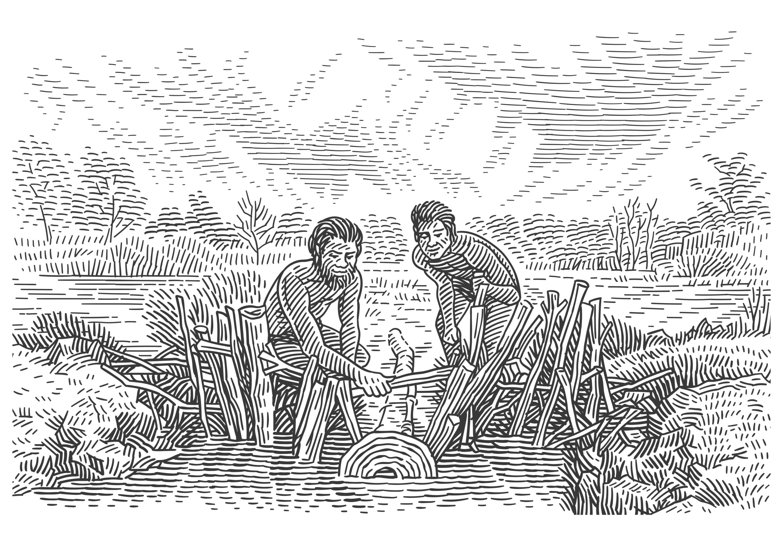
If you could travel back in time to when the aquaculture system was in active use, you might observe workers carefully adjusting the stonework, perhaps replacing the basalt in an area where older stones had fallen away or adding in a new section. Researchers believe the ancient engineers “continually modified the system.” The stones formed a complex network of artificial channels–some over a thousand feet long–that diverted water to shepherd migrating eels and fish. Some of the aquatic creatures were driven into hand-woven nets for immediate harvest, and others were guided into holding ponds or pens to be collected later. All in all, there were at least 70 functional aquaculture systems. In those artificial ponds, the corralled eels grew fat, feeding on local insects, water snails, frogs, and small fish, until the time came for them to be eaten. Woven baskets set in weirs built from volcanic rock and wooden lattice structures would then capture the seafood.

Walking away from the elaborate trap system to visit the settled community nearby of perhaps 600 people–although that population estimate is likely to be revised upwards–built on the edge of the waterways, you would have seen numerous stone huts with fireplaces. You would have also seen women weaving baskets for the weirs used to cull mature eels, men returning from the eel traps hauling a fresh harvest in such baskets, and people preparing the eels for consumption, first by cleaning and gutting them. And you would have witnessed them smoking the rich, oily eel meat with burning leaves from blackwood trees. Researchers have found eel lipids in the earth beneath burnt, hollowed-out trees, suggesting that they were used as family cooking hearths and smokehouses to prepare the eels for trade with other tribes.

Smoking is often considered humanity’s earliest method of meat preservation, allowing meat to be stored for the off-season as well as transported and used as a trading commodity. By drying out the flesh, smoking makes it less hospitable to bacteria that need moisture to grow, and chemicals released from the smoke have antibacterial properties that further safeguard the meat. Smoking also cooks the eel meat, which is poisonous when raw. Eel blood contains a potentially deadly toxin that cramps muscles and can stop the heart from beating. Cooking breaks down the toxin. The Gunditjmara served the eels in a variety of ways. The eels’ bones and skin could be used to create flavorful cooking stock, and the meat could be complemented with local plants such as kelp and saltbush.

For millennia the aquaculture system yielded a reliable food supply, and it was still in use when the British came to the area in the 19th century and provided the first written accounts of the elaborate stone-walled facilities. In 1841, the British colonial official and preacher George Augustus Robinson arrived on an exploratory expedition and described the aquaculture system as “resembling the work of civilized man.” But he also noted, evidencing the prejudices of the era, that “on inspection I found [it] to be the work of the Aboriginal natives, and constructed for the purpose of catching eels.”

“It is hardly possible for a single fish to escape,” he continued. “[T]riple water courses led to other ramified and extensive trenches of a most torturous form.”

Today the Gunditjmara people co-manage, along with the Australian Government, the Budj Bim National Park, which encompasses the ruins of the sprawling Budj Bim aquaculture system. Some of the descendants of the ancient engineers and fishermen who masterminded the aquaculture complex still catch eels and cook them using traditional methods. Various Australian localities even hold eel festivals celebrating eel recipes, both ancient and modern.

Budj Bim in southeastern Australia

A steady supply of food is necessary for any society to function. Budj Bim demonstrates the antiquity of humanity’s quest to stave off hunger by deliberately managing the environment. For millennia the Gunditjmara transformed and enriched their local ecosystems with clearing-fires, stone infrastructure, and artificial ponds. Their elaborate system of water manipulation to systematically trap, store and harvest seafood represents one of the oldest aquaculture systems in the world. For those reasons, Budj Bim is fittingly our thirty-second Center of Progress.

Blog Post | Infrastructure

Centers of Progress, Pt. 35: Agra (Architecture)

The Indo-Mughal architecture of Agra represents a high point of human achievement in the arts.

Today marks the thirty-fifth installment in a series of articles by HumanProgress.org called Centers of Progress. Where does progress happen? The story of civilization is in many ways the story of the city. It is the city that has helped to create and define the modern world. This bi-weekly column will give a short overview of urban centers that were the sites of pivotal advances in culture, economics, politics, technology, etc.

The thirty-fifth Center of Progress is Agra during the city’s golden age at the time of the Mughal Empire (1526–1857). In Agra, different cultures converged to create what many believe is humanity’s greatest architectural achievement: the Taj Mahal (constructed 1631–1653).

Located on a broad plain on the banks of the Yamuna River in the Indian state of Uttar Pradesh, Agra is home to roughly 1.6 million people. The city is known for its leather goods, handwoven carpets, stone handicrafts, and distinct red sandstone. It is also known for its Mughlai cuisine, which has evolved considerably from the days when Mughal emperors dined on food flecked with silver. As a major road and rail junction, as well as a prong of India’s “Golden Triangle” tourist circuit, Agra is a transportation hub. Tourism is a major factor in Agra’s economy, and the city contains two UNESCO World Heritage Sites: the Agra Fort and the Taj Mahal.

The area where Agra now stands has attracted notice since ancient times. Agra is referenced in the ancient Sanskrit epic poem the Mahabharata, which mentions “the forest of Agravana.” But it was the famed Greek scholar Claudius Ptolemy, who lived in Alexandria nearly four thousand miles away, who provided history’s first recorded use of the name “Agra.” “[I]t is easy to recognize the Yamuna, the river which after passing Delhi, Mathura, Agra, and other places, joins the Ganges,” Ptolemy noted in his work Geographia (The Geography), published in AD 150. 

Despite these ancient roots, according to tradition, Agra was founded in the year 1504, when Sultan Sikandar Lodi made it the capital from which he and later his son, Sultan Ibrahim Lodi, ruled over the Delhi Sultanate.

But Agra truly rose to prominence under the Mughal Empire, founded by the Uzbek-born chieftain Babur (1483–1530) in 1526, who conquered Agra and took the younger Lodi’s throne. He had the Ram Bagh, or the Garden of Relaxation, laid out on the banks of the river Yamuna, where it remains as the oldest extant Mughal garden. Babur’s daughter-in-law Empress Bega Begum began the dynasty’s tradition of palatial tombs on the Indian subcontinent in 1558 when she commissioned an elaborate final resting place for her husband, Babur’s son, the second Mughal emperor Humayun. Created by architects from Persia and representing the first garden-tomb in India, this impressive structure in Delhi would soon be dwarfed by the tombs of Agra. 

The empire greatly expanded under Humayun’s son, the third Mughal emperor, Akbar the Great (1542–1605). Akbar focused on both territorial and commercial expansion, conquering land and strengthening trade ties with neighboring realms. Agra’s population swelled under Akbar, reaching as many as 800,000 people.

Akbar redesigned and raised the towering ramparts of the Agra Fort and commissioned the 15-story-tall Buland Darwaza, or “Door of Victory,” just outside of Agra, which remains the highest gateway in the world. Akbar was, for his era, unusually tolerant of other religions. He repealed the customary tax on non-Muslims (the jizyah) and ended the death penalty for de-converting from Islam to Hinduism. He created a religious institution known as the Ibādat Khāna (“House of Worship”), which encouraged interfaith philosophical and theological debates.

Akbar also personally engaged in a radical experiment in religious syncretism, promulgating what some historians describe as a spiritual training program and others call a new religion. The movement, called Din-i Ilahi, attempted to reconcile and merge Islam, Hinduism, and Zoroastrianism and incorporated elements from Christianity, Jainism, and Buddhism. Akbar sought to promote what he saw as the best aspects of these different faiths – such as Hinduism’s encouragement of vegetarianism and Islam’s central tenet of Tawhid, or monotheism. Many of his Muslim contemporaries considered the emperor a heretic (as do many Muslims today), but Akbar’s unusual views helped increase his popularity among his many Hindu subjects.

Akbar took up various native customs, participated in Diwali and other local festivals, and showed an enthusiasm for Sanskrit literature, which he had translated. His son Jahangir and grandson Shah Jahan also would not eat beef in deference to Hindu beliefs. Multiculturalism continued to define the Mughal Empire for centuries after Akbar’s death and influenced the architecture of Agra.

Akbar’s tomb lies in Sikandra on the outskirts of Agra. Constructed from the local deep red sandstone and decorated with beautiful calligraphy and geometric patterns, the tomb combines Muslim and native Indian art styles. The tomb is noted for its four white marble chhatri (dome-shaped pavilion)-topped minarets, which may have inspired similar features in the Taj Mahal. The body of Akbar’s favorite wife, Mariam, rests in another elaborate tomb, also in Sikandra.

But Agra’s most prominent tomb, besides the Taj Mahal, is the Tomb of I’timad-ud-Daulah. Nicknamed the “Baby Taj,” it is a direct forerunner to the Taj Mahal. I’timad-ud-Daulah was a Persian-born Mughal official who served as Prime Minister under Akbar’s and Mariam’s son, Emperor Jahangir (1569–1627), and whose daughter married Jahangir. Built between 1622 and 1628, the tomb signifies an evolution from the first phase of monumental Mughal architecture–primarily built from red sandstone, as in Humayun’s and Akbar’s tombs–to a new phase, with perhaps an even more pronounced mixing of different architectural traditions. The choice of white marble may have been influenced by Hindu practices “set out in the Vishnudharmottara Purana [a sacred Sanskrit text], which recommended white stone for buildings for the Brahmins.” 

Intercultural synthesis was a key characteristic of Agra’s Mughal architecture, which mixes Indian, Persian, and Turkish styles, among others. Islam more broadly has a tradition of syncretizing different architectural styles, such as in the Mosque-Cathedral of Córdoba and the Royal Alcázar in Seville. While Muslim architects likely drew inspiration from their faith—a famous hadith says, “God is beautiful and loves beauty”—they were also constrained by it: a prominent interpretation of Islam prohibits depicting people or animals. As a result, Muslim artists often avoided sculpting or painting people and animals (with notable exceptions such as the “Persian miniature” painting tradition), instead developing expertise in calligraphy, poetry, and art based around abstract geometric patterns. These aniconic designs are among the most distinguishing features of Islamic art and decorate objects of all types, from carpets to stoneware. Alongside calligraphic inscriptions, they also prominently adorn the surfaces of monumental Islamic architecture. Even these distinctive patterns, though, are ultimately the result of cultural intermixing. According to the Metropolitan Museum of Art:

While geometric ornamentation may have reached a pinnacle in the Islamic world, the sources for both the shapes and the intricate patterns already existed in late antiquity among the Greeks, Romans, and Sasanians in Iran. Islamic artists appropriated key elements from the classical tradition, then complicated and elaborated upon them in order to invent a new form of decoration that stressed the importance of unity and order.

Continuing the virtuous cycle of artistic intercultural borrowing, many notable Islamic geometric designs–like arabesques, or interlaced tendril patterns, and Girih, or angular knotlike patterns–inspired Christian artists in Italy and elsewhere. Arabesque is, in fact, a French word derived from the Italian term arabesco, meaning “in the Arab style.” Artistic inspiration flowed in both directions, with Muslim and Christian artists and architects continuously borrowing ideas from one another. For example, the elegant pietra dura or parchin kari jewel-inlaying technique, mainly developed in Renaissance-era Florence with the generous patronage of the Medici family, was used prominently in Mughal artworks. Agra’s “Baby Taj” made ample use of that inlay technique, but the most elegant use of pietra dura in architectural history is widely considered to be in the Taj Mahal itself.

The Taj Mahal was commissioned by Jahangir’s son, the grieving Emperor Shah Jahan (1592–1666), for his favorite wife, Mumtaz Mahal (1593–1631), meaning “Jewel of the Palace.” “Taj Mahal” is derived from her name. While Shah Jahan had two other wives, they were consequences of political marriages, and he largely ignored the former. The emperor was famously inseparable from Mumtaz Mahal, who accompanied him on his imperial travels and even his military campaigns. 

Tragically, even an emperor’s family was not safe from the horrifically high rates of child mortality and maternal mortality at the time. Mumtaz Mahal died at age thirty-eight from birth-related complications. Only half of her fourteen children survived to adulthood, with four dying in infancy, one dying at age one and a half, one dying of smallpox at age three, and another dying of smallpox at age seven. 

According to legend, as Mumtaz Mahal lay dying, she bound her husband with a promise to build her the most beautiful mausoleum known to man.

The Taj Mahal was built in twenty-two years by over twenty thousand artisans, some summoned from as far as Italy and Persia. The prominent calligraphic adornments are thought to be the work of Amanat Ali Khan Shirazi, the Persian brother of Shah Jahan’s prime minister. Ran Mahal, from Kashmir, the northernmost region of the Indian subcontinent, is believed to have designed the complex’s magnificent gardens. One controversial theory claims that a Venetian jeweler living in Agra, Geronimo Veroneo, played a part in the design of the Taj Mahal. The main architect was likely Ustad Ahmad Lahouri, a Persian who may have hailed from modern-day Pakistan or Afghanistan. Ustad Isa from Shiraz in the Safavid Empire (modern-day Iran), who may have also been part Turkish, is credited with the site plan. Shah Jahan himself played an active role in the Taj Mahal’s design, making “appropriate alterations to whatever the skillful architects had designed after considerable thought and would ask the architects competent questions.”

The Taj Mahal’s building materials also came from near and far, with its famous white marble brought from the neighboring province of Rajasthan, the jasper from Punjab, and the jade and crystal adornments from China. Lapis-lazuli, cornelian, mother of pearl, agate, and emerald were also among the precious gems and stones used in the Taj Mahal’s design. The building is thought to have cost around 1 billion 2020 U.S. dollars. Peter Mundy, an Englishman living in Agra at the time, described the construction this way (with spelling modernized for readability):

This King is now building a sepulcher for his late deceased Queen Taj [Mumtaz] Mahal… He intends it shall excel all other[s]… The building is begun and goes on with excessive labor and cost, prosecuted with extraordinary diligence, gold and silver … and marble.

There is widespread international agreement that the Taj Mahal represents a pinnacle of architectural beauty. Type “most beautiful building” into an internet search engine, and chances are the Taj Mahal will appear. The Google Arts & Culture website on the Taj Mahal says, “It is considered the most beautiful building ever constructed.” The Encyclopedia Britannica says, “One of the most beautiful structural compositions in the world, the Taj Mahal is also one of the world’s most iconic monuments.” National Geographic similarly notes, “The Taj Mahal is widely considered one of the most beautiful buildings ever created.” The Metropolitan Museum of Art concurs, counting the Taj Mahal “among the most beautiful buildings in the world.”

The Taj Mahal’s famed tomb forms the centerpiece of a 42-acre complex, which also includes a mosque and a guest house. These architectural wonders stand in a sprawling garden enclosed on three sides by ornate domed and crenelated red sandstone walls. The tomb’s main dome is nearly 115 feet high. The palace-like structure is famed for its proportionality, sumptuous attention to detail, and symmetry. It looks the same from all sides, except the one facing the Yamuna River, which was the mourning king’s entrance–he would take a barge across the river to pay his respects to his late wife. The acoustics of the Taj Mahal’s interior are notable, having, according to the monument’s official government website, “a reverberation time (the time taken from when a noise is made until all of its echoes have died away) of 28 seconds providing an atmosphere where the words of the Hafiz, as they prayed for the soul of Mumtaz, would linger in the air.” (A Hafiz is someone who has memorized the Quran).

Shah Jahan claimed the Taj Mahal’s beauty made “the sun and the moon shed tears.” He is said to have attempted to make the tomb an earthly replica of the palace he believed Mumtaz would inhabit in paradise. The Indian Nobel Laureate Rabindranath Tagore described the Taj Mahal as a “teardrop on the cheek of eternity.” The Persian poet Kalim Kashani wrote, “It is a [piece of] heaven of the color of dawn’s bright face, because from top to bottom and inside out it is of marble… The eye can mistake it for a cloud.” The Taj Mahal has also been called “a poem in stone.” It is also one of the New Seven Wonders of the World.

The last of the Mughal rulers to commission notable architecture was Shah Jahan and Mumtaz Mahal’s son Aurangzeb (1618–1707), who was not especially interested in architecture but had two impressive mosques built as well as the Bibi Ka Maqbara (“Tomb of the Lady”) for his wife–which closely resembles the Taj Mahal. Rather than build a separate tomb for his father, Aurangzeb had Shah Jahan interred next to Mumtaz Mahal. (Mumtaz Mahal lies in the center of the Taj Mahal, and Shah Jahan’s asymmetrical placement to her side suggests the tomb was originally meant to hold Mumtaz Mahal alone). Agra’s architectural wonders continue to attract thousands of visitors from around the world each year.

Taj Mahal, Agra, India

While tastes differ, and some may favor different architectural styles—perhaps preferring the Gothic arches of Westminster Abbey in London or the Art Nouveau masterpieces of Antoni Gaudí in Barcelona—there is little doubt that Agra is home to some of the most impressive and visually pleasing architecture ever constructed. Much like the Renaissance paintings of Florence or the classical symphonies of Vienna, the Indo-Mughal architecture of Agra represents a high point of human achievement in the arts. Agra demonstrates the artistic potential of intercultural borrowing and exchange. It is for these reasons that 17th-century Agra can claim its place as our 35th Center of Progress.

Blog Post | Environment & Pollution

Wealth and Technology Can Overcome Nature’s Wrath

Like the Dutch war against the waves, fortifying against the climate is a technical challenge that requires engineering and adaptation.

The rising sea could become a problem for many, but for the Dutch, it is merely an old and well-known enemy. Trapped between some of Europe’s largest rivers and the violent North Sea waves, the people living in the Netherlands prevent floods for a living – literally.

Holland is a flat, low-lying country on the edge of a stormy sea. To make matters worse, between 20 and 40 percent of its land area is at, or below, sea level. Yet, as the Dutch have shown for centuries, it is possible to live below the water level with appropriate water management and technology.

The Dutch have played an outsized role in the history of the world – in foreign trade, economic growth, and financial development. Their tolerant ethics may have kicked off the Great Enrichment, thus producing the world’s first modern economy. The Dutch also invented central banking and perfected the art of public debt and securities markets. Most impressively, they accomplished all that while under constant siege from the ocean.

The water level on Dutch shores has increased steadily for over 3,000 years (and even more rapidly for 7,000 years before that). In other words, long before the Industrial Revolution, modern capitalism, or the burning of fossil fuels, the Dutch had to adapt – a strategy reviled by purist climate change activists.

Since the twelfth century, local and regional institutions known as waterboards have operated independently of political power. Using dikes, sluices, canals, and other forms of hydraulic engineering, they “began to tame, though never to vanquish, the waterwolf,” writes William teBrake, a history professor at the University of Maine and long-time student of Dutch land history. 

Later, with advanced technology and greater wealth, the Dutch built pumps to drain flooded areas and even, in grand land reclamations, the ocean itself. In modern times, they raised protective barriers to seal off the hinterlands from storm surges.

The threat from water grew worse over time as humans tried to eke out a living from the land. Cutting and burning peat and draining swamps undermined the land’s support and made it drop further below sea level. This process, known as subsidence, sunk the land up to 2 centimeters per year in the late-Middle Ages. That’s five times the rate at which sea levels currently rise around the world and more than twice what the IPCC projects as the worst-case scenario for the rest of this century.

Still, the Dutch prevailed. Somewhere between A.D. 1600 and A.D. 1800, the protective measures made possible by Holland’s growing wealth and improving technology began to pull ahead in the race with the ocean. “The Netherlands has learned to live with the fact that sea-level rise is ongoing and accepts that associated impacts are a continuous issue,” writes Mark van Koningsveld and co-authors in a 2008 article about the Dutch and sea-level rise. “Future problems of climate change and sea-level rise are part of this evolution rather than something fundamentally new.”

The more modern and elaborate protective barriers and sluices, like those in the Delta Works or the Zuiderzee Works, sometimes draw ire because they were constructed only after massive storms destroyed many lives (1953) and property (1916). That is true but also somewhat unremarkable: throughout the thousand-year-plus history of settlement in the Low Countries, it always took extraordinary events for people to spend scarce labor, capital, and material to ensure and refine their survival. Learning how to manage water and protect low-lying lands from the ocean was a trial-and-error process.

If climate change today turns out to increase those water-related risks, the Dutch are rich and technologically savvy enough to supplement their already extensive water protection systems – not unlike what you do with your home or car insurance when your circumstances change. Besides, it’s much cheaper to reinforce a structure than to reverse centuries of carbon emissions.

Of course, it cost a lot of money to build the engineering wonders that currently keep the Netherlands safe from the ocean, but at 0.4 percent of the central government’s annual expenditure, the maintenance of the vast water protection system is likely cheaper than what it was the past.

Even though millions of people in the Netherlands live under the waterline, it’s unlikely that they’ll ever be seriously harmed by a gradual rise in sea levels. But what about larger storms – a problem that the IPCC expects to worsen? Could bigger than anticipated storms overwhelm Holland’s coastal defenses? Luckily, the IPCC report on the oceans from 2019 projects wave heights to decrease in the North Atlantic and the Mediterranean Sea – even under the worst RCP8.5 scenario.

So, can the Dutch relax? Not quite. Their long battle against the ocean to their West and North, and the continental rivers to their East and South, may never end. Water doesn’t rest, but neither do the Dutch, who regularly expand, improve, and comprehensively re-assess their Delta program. If it turns out that climate change is worse than what today’s experts predict, the Dutch can adjust.

Fortifying our societies against the climate is a constant challenge. But like the Dutch war against the waves, fortification against nature’s whims is a technical problem that requires engineering and adaptation, not fearmongering.

Blog Post | Infrastructure & Transportation

Centers of Progress, Pt. 25: Chicago (Railroads)

Introducing the city at the center of the rail revolution.

Today marks the twenty-fifth installment in a series of articles by HumanProgress.org called Centers of Progress. Where does progress happen? The story of civilization is in many ways the story of the city. It is the city that has helped to create and define the modern world. This bi-weekly column will give a short overview of urban centers that were the sites of pivotal advances in culture, economics, politics, technology, etc.

Our twenty-fifth Center of Progress is Chicago during the Age of Steam. Chicago played a central role in the popularization of rail transportation and is the most important railroad center in North America today.

With around 2.7 million inhabitants, Chicago is the third most populous city in the United States. It is a major hub of commerce, boasting a diverse economy. As the city that erected the first modern skyscraper in 1885, Chicago is well-known for its distinctive buildings and other contributions to architecture. For example, the so-called Windy City is home to the 1,450-foot-tall Willis Tower, previously called the Sears Tower. That structure was the tallest building in the world for almost a quarter century. It is still the third-tallest building in the United States, and its observation deck now serves as a tourist attraction.

The city is also famous for its music, food (such as the city’s signature deep-dish pizza), arts scene, sports (particularly the storied Chicago Cubs baseball team), and research universities. Those include Northwestern University and the University of Chicago. The latter gave the world the influential Chicago school of economics. Chicago is a cultural mixing bowl with large Italian-, Polish- and Irish-American populations, among others. Every year, during the St. Patrick’s Day celebration, which honors the patron saint of Ireland, the Chicago River that flows through the city is dyed green.

Even putting railroads aside, Chicago is an important transportation center. The city’s O’Hare International Airport ranks as the sixth busiest in the world and the third busiest in the country. And the area surrounding Chicago has the largest number of federal highways in the United States.

The site where Chicago now stands was first inhabited by various native tribes. Chicago’s attractive location between the Great Lakes and navigable Mississippi River waterways made it a transportation center even then. The first non-native settlers of the area spoke French. The name “Chicago” comes from the French pronunciation of a word used by the local indigenous people for a kind of wild garlic that grew abundantly in the area. (In fact, the vegetable still abounds and can be found in many Chicago restaurant dishes and artisan grocery stores).

The first non-indigenous Chicagoan was Jean Baptiste Point du Sable (before 1750–1818), a frontiersman of African descent who married a native woman and settled in the area. He made a living as a trader and is widely considered to be “Chicago’s founder.” Point du Sable’s business flourished and made him into a wealthy man. The small settlement he began at the mouth of the Chicago River would one day help to enrich humanity.

Chicago was rural at first. The town was officially incorporated in 1833 with a modest population of just 350 residents. However, the settlement was surrounded by rich farmland and well-situated to transport food by boat throughout the Great Lakes region. As early as the 1830s, entrepreneurs saw Chicago’s potential as a transportation hub and began buying land in a flurry of speculation. By 1840, the little “boom town” boasted four thousand inhabitants. By 1850 it had almost thirty thousand people.

Then the trains started arriving, and the city was never the same. Chicago’s inaugural railroad was the Galena and Chicago Union. It welcomed its first locomotive, “The Pioneer,” on October 10, 1848. Nearly overnight, the city became a major commercial center. In 1852, one Chicagoan asked, “Can it be wondered at, that our city doubles its population within three years; that men who were trading in small seven-by-nine tenements, now find splendid brick or marble stores scarcely large enough to accommodate their customers?”

A stunned British visitor to Chicago during the 1850s wrote, “The growth of this city is one of the most amazing things in the history of modern civilization.” He referred to Chicago as “the lightning city.” Starting in 1857, durable steel rails—still the standard around the globe—replaced cast-iron rails. That innovation allowed trains to move twice as fast as before, greatly improving trains’ practicality and further boosting steam transportation.

Chicago’s rapidly rising population brought new public health challenges. An insufficient waste-drainage system allowed pathogens to infect the water supply and caused outbreaks of illnesses such as typhoid and dysentery. One 1854 bout of cholera killed six percent of the city’s population. Recognizing the problem, private property owners and city leaders cooperated to improve the city’s drainage system in the late 1850s and 1860s. To make room for new sewers, they lifted the city fourteen feet in a Herculean feat of engineering. The “Raising of Chicago,” as the endeavor came to be known, was accomplished piecemeal by lifting the city’s massive brick buildings, streets, and sidewalks using large jackscrews operated by hundreds of men. If that is difficult to imagine, here is a visual. It was perhaps the most striking event of the modern sanitation movement that Nobel Prize-winning economist Angus Deaton partly credits with the dramatic rise in human life expectancy.

By 1870, Chicago’s population had grown to almost 300,000 souls. Then tragedy struck. On a series of dry October days in 1871, a fire swept through Chicago. The flames claimed some 300 lives, destroyed around 17,500 buildings, and left more than 100,000 Chicagoans (i.e., over a third of the city’s people) homeless. According to legend, the Great Chicago Fire was sparked by a lantern kicked over by a cow belonging to Catherine O’Leary (1827–1895), an Irish immigrant. The fire’s true origin remains a mystery. But the tale of “Mrs. O’Leary’s cow” has entered popular culture, appearing in numerous songs and films. Regrettably, the story was fueled by anti-Irish sentiment. Chicago’s city council officially exonerated the O’Leary family and the infamous cow in 1997, to the relief of Mrs. O’Leary’s great-great-grandchildren.

Chicago rose from the ashes like a mythic phoenix to make its greatest contributions to human progress. After the Great Chicago Fire, the city was rebuilt around the rail industry. Chicago’s central location helped the city to contribute to the meteoric rise of rail-based commercial transportation. Recognizing Chicago’s prime location, most railroad companies building westward chose the city for their headquarters. The city thus also became a major manufacturing center for railroad equipment.

The roar of passenger and freight trains soon filled the air around the city’s six bustling inter-city terminals. Municipal and regional commuter trains also appeared and redefined intracity transport. Chicago’s Union Station still looks as it did during the Golden Age of rail and is today the United States’ third busiest train station.

Recent research suggests that the development of a nationwide transportation system, particularly railroads, helped the United States urbanize and industrialize in the 19th century. The “transportation revolution” made it easier for rural workers to relocate to urban locations and take up manufacturing work. Trains also let goods flow more quickly across the country, allowing for greater regional economic specialization. As the country’s Northeast region industrialized, the Midwest earned its nickname, “America’s Breadbasket,” by producing wheat to support the country’s swelling population.

Freight trains loaded with goods from other cities arrived at the central yards of Chicago. There, workers classified the goods. They then transferred the arrivals to massive sorting yards on the city’s outskirts.

As Chicago prospered, the city became a center of culture and innovation, with particularly notable contributions to transportation technology. As host of the Chicago World’s Fair in 1893, Chicago gave humanity several new inventions. Those included the Ferris Wheel (also called the Chicago Wheel), the moving walkway, and the first third rail.

By 1900, Chicago was the fifth most populous city in the world and the second most populous in the United States, after New York City. If you could visit Chicago during the Age of Steam, you would enter a city jam-packed with pedestrians, horse-drawn carts, streetcars, and, of course, trains. Around two thousand trains, including freight trains, arrived and departed the city each day. Rail transport had come a long way from the days when people doubted whether steam-locomotives could outrace horses.

Steam transportation helped create the modern world, and no city was more central to the so-called rail revolution than Chicago. It was once commonly said that “all roads lead to Rome.” That city’s groundbreaking road system earned Rome its place as our ninth Center of Progress. Today, it could as easily be said that “all railways lead to Chicago.” For lending steam to urbanization, industrialization, and ultimately the Great Enrichment, Chicago during the Golden Age of train travel is rightly our 25th Center of Progress.

Blog Post | Infrastructure

How the Dutch Tamed the Waters

If the Dutch could beat back the encroaching waves in the 17th and 18th centuries, why couldn’t low-lying developing nations today also overcome gradual changes in sea level?

Britannia may once have ruled the waves, but it was the Dutch who tamed the sea. In water management and beating back a rowdy ocean, the Dutch are undisputed champions—a title they have proudly held for a long time. Some of the iconic Dutch windmills, for instance those at Kinderdijk, were built hundreds of years ago explicitly to empty the surrounding lands of water. The first dikes and dams in these lowlands were most likely constructed over 2,000 years ago, probably by Romans or Frisians.

For centuries, the people living along the Atlantic coasts have carved off and dammed areas when the tide went out, gradually drying saltmarshes and expanding land suitable for agriculture. Today upwards of one-third of this prosperous northern European nation’s territory lies below sea level. Yet, as the Danish writer Bjørn Lomborg puts it, nobody here “needs scuba gear to get around.” The reason, explains the information site Netherlands Tourism proudly, is that the Dutch have “one of the most sophisticated anti-flood systems in place anywhere in the world.”

Considered one of the modern wonders of the world, some of the storm surge barriers that today protect the low-lying Netherlands are kilometers long. The Eastern Scheldt Storm Surge Barrier, for instance, consists of 62 steel slides in-between concrete pillars almost 40 meters high and weighing over 18,000 tons. During normal times, they allow for the free flow of water and fish with a flourishing aquatic ecosystem. When a particularly large storm approaches, the barriers can be lowered to protect the land beyond.

The Eastern Scheldt is just the largest of the 13 grand dams and barriers that make up the Delta Works. Another impressive structure is the Maeslant Barrier on the main waterway to Rotterdam, Europe’s largest seaport. Consisting of two 210-meter long and 22-meter high hollow steel gates that usually rest in adjacent dry docks, the gates swing out and close the waterways when storm surges of at least 3 meters are predicted. When closed, the gates form a next-to-watertight protective barrier. 

The Dutch are squeezed by water from all sides. Still, rather than being subject to the whims of nature, the Dutch are masters of their fate. To mark their achievement, next to the Storm Surge Barrier in Eastern Scheldt is an inscription. In Dutch, it reads “hier gaan over het tij, de maan, wind en wij,” which can be translated as “The tide here is ruled by Thee: Moon, Wind, and We.” It’s not for nothing that a common Dutch saying is: “God created the Earth, but the Dutch created the Netherlands.”

The creation of these elaborate water protection systems is usually credited to government action after the 1953 storm that killed over 2,000 people. As the badly-maintained levees, which were damaged in World War II, gave way to an unusual combination of a high spring tide and severe storm, the waters rushed through thousands of hectares of houses, pastures, and people. Over the next four decades, the Dutch constructed dams, protective barriers, and ever-more sophisticated systems such that the devastation they saw in “The ‘53” would never happen again.

The construction of these supreme feats of engineering—roughly from the 1953 storm to the final inauguration of the Maeslant Barrier in 1997—cost about 5 percent of the GDP, over several decades. The annual upkeep of the full Delta Works programs, financed out of the taxpayer-funded Delta Fund, comes to $1.8 billion per year, which is equivalent to 0.2 percent of the Netherlands’ GDP in 2019. 

The Maeslant has been closed a handful of times, and the Eastern Scheldt barrier at least 27 times—most recently in the February 2020 storm Ciara. The number of Dutch deaths from flooding since the Delta Works became operational has been zero.

But the Dutch mastery over the sea didn’t begin in 1953. For centuries, local water boards (or “polder boards”) maintained dunes, water protection-fortifications, streams, and trenches. They levied fees on the population in their local catchment area, bypassing political disputes in the capital.

Some of the oldest living financial documents are perpetual bonds from these water companies that, almost four centuries later, are still paying interest on money raised in the 1640s. Yale financial historian William Goetzmann writes in Money Changes Everything that:

Whether the country was run by the Spanish, French, or Dutch, the water companies maintained power of taxation and the ability to raise their own armies in times of need – armies to fight floods. […] Without their own capabilities, the great threat to the citizens would not be from their neighbors but from the ever-present risk of inundation.

Sea level rises—from a warming planet, thermally expanding oceans, and melting ice caps, ice sheets, and glaciers—may be new worries in a world sensitive to climate change. But, adaptation and innovation aren’t new to the Dutch. Generation after generation of people living along the Dutch Atlantic shore has fought an uphill battle with an encroaching sea. Relentlessly draining lands through clever use of canals, ditches, sluices, barriers, windmills to pump away water, and persistently pushing back the sea, the Dutch have overcome their oceanic challenge.

The United Nation International Panel on Climate Change reports that the global average sea level rose by about 20 centimeters between 1901 and 2010. Yet, over the same period, the Dutch expanded their land area by tens of thousands of square kilometers! The Dutch, in other words, show us that even poor countries by modern standards can come out victorious from a fight with the elements.

If the Dutch could beat back the encroaching waves while being much poorer and less technologically advanced than most people in the world today, why couldn’t low-lying, developing nations today also beat the threat that is gradual sea level rises? Vietnam now has the GDP per capita of the Netherlands in the late 1940s; Bangladeshis are, on average, as rich as the Dutch at the start of the 20th century. But the Dutch mastered the ocean already in the 17th and 18th centuries!

In his long read from January this year, Financial Times journalist Simon Kuper wrote that “whenever a city starts thinking of protecting itself against floods, someone will say: ‘Bring in the Dutch.’” Indeed.