Jakarta floods, and Jakartans tweet. When they wake up in the morning and see the thick smog of car exhaust and coal fumes outside the window, they tweet. When they realize the road is blocked because of high water, they tweet.
During a three-month period in 2013, when Indonesia was still relatively early in its digital boom, Jakarta was already contributing around 2.4% of all posts on Twitter worldwide, according to social media monitoring firm Brand24. That year, nearly 50 people died in floods that led to 20,000 people being evacuated. There were other devastating inundations in 1996, 2002, and 2007.
Today, if a Twitter user in Jakarta tweets the word “banjir,”which means flood in Indonesian, they get a jaunty response from a Twitter account with the handle @PetaBencana: “Hi, I’m Disaster Bot. To report flooding near you, reply with #flood.” If they do that, the bot will send them a link to a site where they can locate the flood on a map, report how high the water is, and submit a photo of the damage.
This is how PetaBencana, which translates as Disaster Map, produces real-time, crowdsourced maps of emerging disasters from social media users, who can also report earthquakes, forest fires, smog, strong winds, and volcanic activity.
In March 2020, when a 5.0 magnitude earthquake hit Sukabumi regency in the west of Java, volunteers trained by the local Red Cross Society (Palang Merah Indonesia in Indonesian) were able to immediately map the damage, which they passed onto relief agencies. During Tropical Cyclone Seroja in this past April, residents of East Nusa Tenggara province used the platform to report collapsed bridges, washed away homes, and power outages through the platform. Earlier this year, when massive floods inundated the city of Jakarta for weeks, news media cited data from PetaBencana to keep residents informed.
Founded in the capital of one of the most disaster-hit countries on Earth, PetaBencana is able to turn social media chatter into a ground-level live view of emerging catastrophes, cutting through the chaotic flow of information that follows a natural disaster. Whereas Indonesian emergency management agencies used to send information in static PDF documents at six-hour intervals, they can now work with PetaBencana to show in real time where help is needed, where roads are still passable, where hospitals are still operating, and where they have been knocked out. It is, experts said, replacing best guesses in the dark with actionable information.
PetaBencana’s success in Indonesia, where it is now used by government agencies, NGOs, and ordinary citizens, has led to it being adopted in the Philippines, Hong Kong and Vietnam. Its founders and supporters say it demonstrates the power of collective intelligence — technology developed from the ground up and led by citizens who are collectively invested in solving community problems.

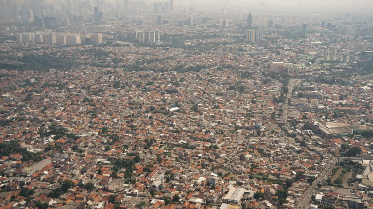
PetaBencana could only have been born in Jakarta. Thirty million people live across the greater metropolitan area, commuting through jam-packed roads and breathing in the smoke and fumes from vehicles and factories, while children play in the murky brown waterways. Some live in skyscrapers, but millions reside in shabby neighborhoods by the city’s rivers and canals.
The city’s 13 clogged rivers overflow whenever it rains; subsidence caused by groundwater extraction means it is actually sinking, and now nearly 90% of its northern districts are already below sea level. Although Jakartans have had to live with flooding for decades, population pressure has sped up the subsidence and clogged the waterways that should drain the cities with waste. Consulting firm Verisk Maplecroft placed Jakarta at the top of the list of cities in the world that have the greatest risk of environmental hazards, including severe air pollution and seismic activity.
Around the Muara Angke fishing port in the north of the city, residents told Rest of World they now experience flooding only twice a month, since the construction of a giant sea wall that stretches across Jakarta Bay. They have gotten used to going about their daily lives with water coming up to their knees, they said.
In Kebon Pala, a residential area that lies just above the Ciliwung river, the largest waterway running through Jakarta, it floods five times a month. Suningsih, 50, has lived in her yellow house by the river bank since 1985, selling rice cooked in coconut milk from a stall. In June, her house was flooded by meter-high water. A few weeks before, she had to evacuate for two days after a flood swamped her home entirely, leaving only the roof dry. “The flooding has become more and more frequent,” she said.
The provincial government of Jakarta has mostly relied on infrastructure development projects to protect residents from flooding, including building canals to divert water and reduce overflows to constructing walls along the rivers and coasts. But when floods occur, the authorities have often struggled to respond quickly.


“One of the issues that [authorities] have is understanding in real time the severity of the flooding in any part of the city,” Tomas Holderness, who was one of PetaBencana’s principal researchers, told Rest of World.
In 2013, Holderness had been a part of a team from SMART Infrastructure Facility, a research group from the University of Wollongong in Australia, that used OpenStreetMap data of Kibera, an informal settlement in Nairobi, to improve the area’s sanitation using crowdsourced data. That same year, at around the time Holderness was wrapping up his Kibera project, the university started a joint study of what would become PetaBencana. They called the project PetaJakarta (JakartaMap). At that point, researchers were just starting to get interested in the potential of Twitter as a data source, according to Holderness.
“We started to see that during extreme weather events, people are talking about these things,” Holderness said. “That was kind of the beginning of the conversation of ‘Hey, how can we use that information in real time?’”
Holderness’ team designed a piece of open-source software called CogniCity, which can “listen” to conversations on Twitter, inviting anyone who uses disaster-related keywords to share more information. The software also plugs itself to other data crowdsourcing applications, such as Qlue and Pasang Mata, and derives information from them.
In early 2014, PetaJakarta was one of the winners of Twitter’s #DataGrant competition, a now discontinued initiative by the platform, which gave the researchers access to a huge amount of the platform’s data. They found that during the 2013-2014 monsoon season in Jakarta, there were more than 150,000 geolocated Twitter conversations about flooding.
Using social media information in humanitarian assistance was not entirely new. In 2010, a Ph.D. student at Tufts University, Patrick Meier, created a crisis map for the Haiti earthquake by manually pulling information from Twitter, Facebook, and YouTube videos. Meier subsequently wrote several papers discussing the potential of social media in disaster response, eventually culminating in the book Digital Humanitarians. Other initiatives followed. In the summer of 2010, several Russian bloggers, inspired by the response to Haiti, launched a “help map” of forest fires in their country. In 2011, when a civil war in Libya prompted a need for humanitarian aid, the United Nations Office for the Coordination of Humanitarian Affairs (UNOCHA) created a crisis map in the same way.
But PetaJakarta’s approach was novel because, rather than just use social media as a one-way source of information, its founders were trying to build a dialogue between the system and its sources.
“You start to have this kind of human filter of saying: Are you being affected by flooding? Tell us more,” Holderness said. “You’re giving people a chance to have a two-way conversation and say, yes, it’s flooding here, or no, it’s not flooding.”
Whenever a user submits a flood report to CogniCity through social media, a water droplet appears on a map on the PetaJakarta website. Clicking on the drop expands it into a report card, containing the details of the report — the flood’s severity, description, precise location, and photos.

In 2015, Bambang Surya Putra was working as the head of informatics at Jakarta’s emergency management agency when he encountered PetaJakarta’s team for the first time. He told Rest of World that the agency saw the potential of the platform from its inception.
“The platform was really helpful for us in the local government because it provides real-time mapping information… so we could delegate a team or provide information to colleagues at the village level more quickly,” Surya Putra said.
PetaJakarta’s approach was novel because, rather than just use social media as a one-way source of information, its founders were trying to build a dialogue between the system and its sources.
Over the following years, the agency has woven the system into its disaster responses. It has built its own feature, called the Risk Evaluation Matrix, or REM, which collates reports from multiple sources, verifies them, and then disseminates the information through the PetaJakarta portal. In that way, the map displays verified information from formal sources alongside crowdsourced information from citizens through social media.
The experience has led Surya Putra to believe that more humanitarian data should be made widely available through open Application Programming Interfaces (APIs). Political barriers have often stopped this from happening, as public officials are reluctant to share information about disasters for fear it will damage their reputations, he said. “For us, information is a form of aid, in addition to money, food, rice, and instant noodles.”
The University of Wollongong study ended in 2015, and Holderness eventually moved to the Massachusetts Institute of Technology (MIT)’s Urban Risk Lab. He continued to support the project while at MIT.
In Jakarta, the remaining team rebranded the platform PetaBencana, to reflect their ambition to go beyond the confines of their home city and to expand into mapping other types of natural disasters. By 2018, the project had outgrown its origins as a university research project, and was spun into its own foundation. Nashin Mahtani, a designer on the project, was appointed its director.
Mahtani studied architecture for both her bachelor’s and master’s degrees at the University of Waterloo in Canada, where she became drawn to observing water infrastructures. “In architecture school, typically you’re learning about buildings. But I was more interested in looking at the larger systems, like landscape infrastructures,” she told Rest of World.

One of the biggest challenges that PetaBencana has faced as it tries to expand to cover more hazards is the disconnect between how relief agencies see a disaster from a distance, and how it is experienced on the ground.
“[The challenge is] how can we design the reporting mechanisms so that if … you perceive risk on a different scale than I do because of where you live, I can still make decisions based on what you’re submitting?” Mahtani said.
Floods, for example, are fairly easy to get standardized reporting on — most people would judge how severe a flood is based on the height of the water. But for people reporting haze — the choking smoke that comes from huge fires in Indonesia’s rainforests — normalized air quality indexes might not have any real resonance. After speaking to communities who were often affected by forest fires, the team realized that people were talking about haze based on their symptoms.
“They would say ‘My eyes are watering,’ or ‘I can’t see,’ or ‘I have a headache and I’m nauseous,’ and we were trying to measure that against the levels that were being read by the government,” Mahtani said. “And then we created a system where for residents to report, they can now input the symptoms they’re feeling, and that is used to classify the severity.”
“We created a system where for residents to report, they can now input the symptoms they’re feeling, and that is used to classify the severity.”
This kind of wisdom of crowds has long been used to try to keep people safe in Indonesia, which sits along the Pacific Ring of Fire, and has a long history of natural disasters. Nearly 100,000 people in Indonesia died during the 2004 Indian Ocean earthquake and tsunami, which affected multiple countries.
Over centuries of close observation, communities have built traditions that help them read warning signs from the Earth. On Simeulue island in Aceh province, a folk song tells the story of smong, an event where people must run to the hills if they feel an earthquake followed by receding sea water. Thanks to this knowledge, only 7 Simeulue people died in the 2004 tsunami. In Palu, Central Sulawesi, the Kaili ethnic group has traditional poems that describe the effect of an earthquake and tsunami, and mark vulnerable and safe areas. When a tsunami hit Palu in 2018, many people who stayed in areas that were marked vulnerable perished, and those who stayed in safe areas survived.
That traditional knowledge has been eroded by urbanization, the effects of the climate crisis, and environmental degradation, which have made disasters more unpredictable, more frequent, and more widespread.
Today, young Indonesians prefer to turn to social media during a disaster. That is why everything in the PetaBencana system, from how the Disaster Bot should greet users to what information appears on the map, is designed to replicate how people were already communicating with each other on social media. As Indonesians move to new social media platforms, PetaBencana has to follow them. They are working to connect their system to Instagram and TikTok, on top of Facebook, Twitter, and Telegram.
Surya Putra, the former regional agency director, who is now the head of the emergency operations center at the national emergency management agency (BNPB), said that this approach has significantly improved their situational awareness during disasters.
For example, if the agency notices on PetaBencana a flood report from a faraway province like Sulawesi, it can immediately ask the local government to check and handle the situation, and provide support if needed. When assessing disaster risk such as forest fires, PetaBencana adds a human perspective to the agency’s extensive network of sensors, in some cases giving earlier warning of impending problems.
“What we need is [human] sentiment. What is the public feeling? What’s going on in there? We cannot possibly reach that without utilizing crowdsourcing technology,” Surya Putra said.
However, he warned that the system would only ever be part of its overall monitoring network, and a “second opinion.”The BNPB’s main monitoring center has 30 screens; PetaBencana is just one of them. He also worries about the potential for misuse and hoaxes. “One could make a fake report using smoke from his cigarette and say, ‘There is smoke!’ Now, to send a helicopter to that false report would be very expensive,” he said.
CogniCity, itself open-source, has now been adopted in the Philippines, Vietnam and Hong Kong to manage urban disasters. Like Indonesia, the Philippines and Vietnam are finding ways to cope with increasingly erratic flooding due to climate change, while India suffers from regular devastating cyclones.


For its creators, PetaBencana is at its most successful when it does more than just take information from the ground and actually enables communities to participate in decision-making.
Indonesia’s disaster approach is often top-down and prescriptive. The disconnect between decision-makers and people on the ground has led to aid being badly-distributed during emergencies, leaving people to fend for themselves.
Critics said that during Indonesia’s attempt to manage rising Covid-19 infections last year, the government did not involve communities before it released its quarantine requirements and travel restrictions. That led to confusion and contradictory messaging. There were reports of regional governors trying to implement their own lockdowns, despite being discouraged to do so by the central government. As a result, Indonesia lost control of the outbreaks. Today, the country has reported nearly 1.9 million Covid-19 cases and over 55,000 deaths.
The emergency director Surya Putra said that this wasn’t inevitable, and that as disasters become more frequent, the government, citizens, academia, the media, and other organizations must all consider themselves active stakeholders in the response. “Let’s say during a flood you see a neighbor stranded on his roof, needing help. Take a photo of him and send a report [to ask for help], and that can be a form of assistance to him,” he said. “It doesn’t always have to be the government who can take action.”
Bringing citizens into disaster response is vitally important to redressing the injustices created and exacerbated by the climate crisis, Mahtani said. Activists have long agreed that people living in poverty, women, and other marginalized groups will suffer the most from the crisis because they lack political power to advocate for themselves and access to protection and safety. Often, women and girls are more affected by disasters because they have less access to information than their male counterparts and are less empowered to position themselves as part of any solution.
“Unfortunately, [climate change] affects those already vulnerable even more. Those are huge, huge structural inequalities we have to address as a society,” Mahtani said.
That is why Mahtani hopes PetaBencana can be a tool for these vulnerable groups to share information with each other, and have the confidence that they too can make evidence-based decisions. In reality, during and after a disaster, people affected at ground zero often are the first responders before everyone else arrives, from yelling warnings to pulling people out of the rubble. “We don’t want to concentrate decision-making in a small group of people who are looking at a dashboard,” she said.